|
The Hudson Valley offers some nice places for bicycle riding where
the interaction with motor vehicle traffic is normally limited to just a
few points, sometimes only at the start and finish.
Many of these places are also good for a group with a variety of
interests and requirements -- inline skates (e.g. "Roller
Blades" trademark), roller skates, wheelchair, jogging, or walking
with a stroller.
Warning: Although the the riding at these places and
routes is mostly off-road, it still has significant risks. These
paths, rail trails, and roads sometimes go right next to drop-offs and
cliffs. There are trees, rocks, and many other obstacles which
can be collided with. Other users can be moving at high speeds
even though they are not motorized, and there can sometimes be motor
vehicles (e.g. authorized maintenance vehicles, unauthorized users) --
so high-speed collisions are possible.
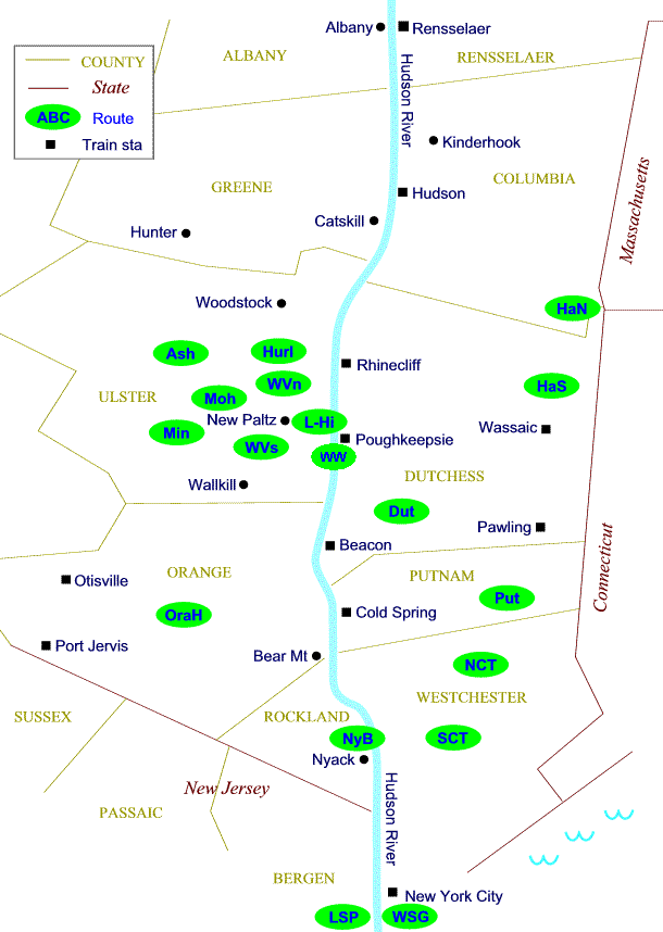
Start points Wassaic train station (Harlem line of
Metro North) or Amenia or Millerton along
Route 22 in eastern Dutchess county. The rail trail goes slightly
uphill in the north-bound direction from Wassaic toward Millerton, so if you
want it easier on your return trip, start in Amenia or Wassaic. Note that although
the trail itself is off-road, it intersects with public roads at several
points, at least one with high-speed vehicle traffic -- so special care is
required in detecting, approaching, and crossing those.
Start point Copake Falls along
Route 22 in eastern Dutchess county (or Under Mountain Road at its south
end). Bicycle shop
and food in Copake Falls. Also suitable for inline skates, roller
skates -- and walking with a stroller or wheel-chair. Note: This
route includes a short section on a
public road, but this normally has very little traffic. It also intersects with
driveways and possibly public roads at several other points -- so special care is
required in detecting, approaching, and crossing those.
As of 2009 there is a northern section near
Poughkeepsie that is paved with asphalt. There is also a southern section near
Hopewell Junction, but we haven't been on that since its construction.
GPS: access to north end of the northern
asphalt section from public roads -- by Morgan Lake (with parking nearby as of
2009) [
on Google Maps ] -- latitude-longitude (approx)
= 41.71750,-73.90727 = N41.71750 W73.90727
access to south end of the northern asphalt section from
public roads -- by Overocker Rd (with parking nearby as of 2009)
[
on Google Maps ] -- latitude-longitude (approx)
= 41.69401,-73.88451 = N41.69401 W73.88451
connections:
* As of 2009 there is no off-road connection
between the Dutchess Rail Trail and the
Walkway over the Hudson.
* north end by Morgan Lake is near
Walkway /
Kingston-Rhinecliff Bridge loop route on public roads with motor vehicle
traffic (which also goes to the Walkway over the Hudson)
* section by Overocker Rd crosses the
connect Poughkeepsie to Salt Point
route on public roads with motor vehicle traffic.
-
Walkway Over The
Hudson
-- Bridge across the Hudson River between
Poughkeepsie and Highland, a rather wide walkway open for bicycling and walking.
Big views up and down the river, especially nice of the road bridge and
river to the south. [
official website ]
Off-road, paved (concrete and asphalt) about 1.5 mile long.
As of 2009 there is no
off-road connection between the Walkway and the
Dutchess Rail Trail or with
the Lloyd-Highland Rail Trail -- but as of 2010 there is a project to
connect with the Lloyd-Highland Rail Trail.
For a 4-mile loop that goes crosses the River twice,
once over the sidewalk of the Mid-Hudson Bridge, but includes more than a mile
on public roads with significant motor vehicle traffic, see
Mid-Hudson / Walkway loop - (loop could also be
used for walking or running, especially for those starting from the Poughkeepsie
train station).
Access to the Walkway is roughly one mile on streets
from the Poughkeepsie train station (service by Metro North and Amtrak from New
York City).
GPS: main access to Walkway east
end in Poughkeepsie from public roads (with parking nearby as of 2009)
[
on Google Maps ] -- latitude-longitude (approx)
= 41.71171,-73.92446 = N41.71171 W73.92446
main access to Walkway west end in Highland from
public roads (with parking nearby as of 2009) [
on Google Maps ]
-- latitude-longitude (approx)
= 41.71014,-73.95522 = N41.71014 W73.95522
back to Top
| back to Map |
text List | main
Routes index
-
Ashokan Reservoir --
2.3 miles (as of May 2004) -- 1 mile, flat, on a wide paved path, plus an
additional 1.3 miles on a wide paved road closed to motor vehicles (as of May
2004) -- but access to the second
section from the usual "Frying Pan" parking area requires traveling
up to 0.1
mile on a road open to motor vehicle traffic. Beautiful views across the largest lake
in the Hudson Valley, and of the highest summits in the Catskill
mountains. Also suitable for inline skates, roller skates,
wheelchair -- or walking with a stroller. Start point Ashokan Reservoir in Ulster county.
See [ Details |
Administration
| Map
| Photos
]
-
Lloyd - Highland Rail Trail -- about
5 miles on pavement with return (out
2.5 miles and then back). Very gentle.
Pleasant riding on a wide paved path, mostly off-road. Additional unpaved section also
open. Also suitable for inline skates, roller skates,
wheelchair -- or walking with a stroller. In town of Lloyd in Ulster
County (near Highland and Mid-Hudson Bridge). See
[ more Details
|
Photos
].
-
Walkway Over The
Hudson
-- Bridge across the Hudson River between
Poughkeepsie and Highland, a rather wide walkway open for bicycling and walking.
Big views up and down the river, especially nice of the road bridge and
river to the south. [
official website ]
Off-road, paved (concrete and asphalt) about 1.5 mile long.
As of 2009 there is no
off-road connection between the Walkway and the
Dutchess Rail Trail or with
the Lloyd-Highland Rail Trail -- but as of 2010 there is a project to
connect with the Lloyd-Highland Rail Trail.
For a 4-mile loop that goes crosses the River twice,
once over the sidewalk of the Mid-Hudson Bridge, but includes more than a mile
on public roads with significant motor vehicle traffic, see
Mid-Hudson / Walkway loop - (loop could also be
used for walking or running, especially for those starting from the Poughkeepsie
train station).
Access to the Walkway is roughly one mile on streets
from the Poughkeepsie train station (service by Metro North and Amtrak from New
York City).
GPS: main access to Walkway east
end in Poughkeepsie from public roads (with parking nearby as of 2009)
[
on Google Maps ] -- latitude-longitude (approx)
= 41.71171,-73.92446 = N41.71171 W73.92446
main access to Walkway west end in Highland from
public roads (with parking nearby as of 2009) [
on Google Maps ]
-- latitude-longitude (approx)
= 41.71014,-73.95522 = N41.71014 W73.95522
-
Hurley
Rail Trail - (as of July 2007) - The paved section runs alongside the east side
of Route 209 near Kingston. Its north parking area is immediately south of
where 209 crosses Esopus Creek, a little more than a
mile south from Route 28. The paved section of the trail is flat, and it's
about 2.1 or 2.2 miles long (one-way). It crosses one public motor vehicle road. Parking
areas are on either end of the paved section, or sometimes we park alongside Russell Rd
(the one that crosses the middle of the trail). The
unpaved section continues south another 5 miles or so to Leggett Rd +
Rt 213 near High Falls (and we've heard that it continues some distance
further south from there). We've also heard that the trail follows the
former path of the Ontario &
Western Railway (O&W) and had some relation to the Delaware and Hudson canal
(D&H). See [
Map ]
Start point New Paltz
in Ulster County, which is conveniently reached from exit 18 of the NYS
Thruway or the Mid-Hudson Bridge and Route 9W. Bike shops and food in New
Paltz. Note that although
the Rail Trail itself is off-road, it intersects with public roads at several
points, some with possible high-speed vehicle traffic -- so special care is
required in detecting, approaching, and crossing those. [ Map
]
Start point
New Paltz
in Ulster County, which is conveniently reached from exit 18 of the NYS
Thruway or the Mid-Hudson Bridge and Route 9W. Alternate start point
Gardiner (on Route 44). Bike shops and food in
New
Paltz, food in Gardiner. Note that although
the Rail Trail itself is off-road, it intersects with public roads at several
points, some with possible high-speed vehicle traffic -- so special care is
required in detecting, approaching, and crossing those. [
Map
| KML |
GPX
]
-
Orange Heritage Rail Trail -- 9
or more miles one-way (or more than 18 miles on pavement with return). Pleasant riding on a paved path, mostly off-road -- additional unpaved section also
open. Also suitable for skates,
wheelchair -- or walking with a stroller. Start points Monroe, Chester, or
Goshen in Orange County. [
more Details
]
-
Rockland Lake bike trail
-- 3 mile loop on a paved path around and alongside the lake. Also
suitable for skates, wheelchair -- or walking with a stroller. Might be
charged a fee for parking or entry. Often has toilets, snack food, swimming
pool open. [not checked by us since 2010]
Rockland Lake State Park [
official
site ] is near Congers, Haverstraw, Nyack.
North entrance -- GPS latitide/longitude (approx) = (41.14733,-73.92689) =
N41.14733 W73.92689,
South entrance = (41.13019,-73.92516) = N41.13019 W73.92516.
[
map |
on Bikely | download
GPX file ]
Start point Nyack Beach State Park
[
map |
Official
web page - - alternate
- - Administration ] in
Rockland county.
Directions: NY Thruway to Nyack exit, Route 59 East, across rt 9W, down hill
into business center of Nyack. At some traffic light, turn Left on Broadway and
go north for a couple of miles or so all the way to its end, then down a hill
into the Park.
GPS latitude/longitude = (41.120875,-73.911037) = N41.120875 W73.911037
"picnic spot" by the River = (41.13893,-73.90688) = N41.13893 W73.90688
connects with
Nyack Beach to Haverstraw
path
-
Saddle River path -- Saddle River
County Park in Bergen County NJ has a beautiful paved path that runs along the
Saddle River for about six miles north-south from the Ridgewood Duck Pond
(just south of Linwood Av and north of Ridgewood Av, and just west of Paramus
Rd) thru Dunkerhook to Railroad Av in Rochelle Park (between Saddle River Rd
and Main St - Fairview Av), with several side paths [as of 2004].
Near Rochelle Park, Glen Rock, Dunkerhook, Ridgewood, Paramus, Fair Lawn.
For info try
Garden Skaters,
Bergen County
Parks. [
see where on map ]
-
Liberty State Park,
New Jersey -- a paradise of flat walkways with brick-stone surface,
and some pavement. Pretty riding right by the water, the very
best views of the Manhattan skyline -- and historical sites and a
modern science center. [
official
Website | Photos
]
Just south of Jersey City and
across the river from Manhattan. Convenient access by car,
light rail in NJ, ferry
boat from Manhattan. Special hazard to watch out for:
beautiful walkways that lead to the top of short stairways -- but
there's always a way to avoid the stairs -- you do have to pay
attention to where you're going.
back to Top
| back to Map |
text List | main
Routes index
Undercliff Rd
has rocks and cliffs, and you can stop and watch the rock
climbers. Overcliff Rd has views out across the Coxing Kill and
Rondout valleys. You can go out as far as you want on either
one -- or fit riders can make it a loop.
The
Mohonk
Preserve is in Ulster county. Day use fee is required. See
where on map or
Map
for Driving. Take the Thruway to exit 18 for New Paltz
(or start from the Mid-Hudson Bridge and take Route 9W North to Route
299 West). Go West on Route 299 through
New
Paltz and continue West several miles to its end at a
T-intersection. Turn Right on Route 44 West. Soon you see
the sign for the
Mohonk
Preserve visitor center on the Right, which has overflow parking.
Continue up the hill around a hairpin curve, on up to the top and under an iron
bridge (Trapps Bridge), then down a little ways to the parking area on the
Right. See
where on map or Map
for Driving.
GPS latitude/longitude (approx) = (41.736671,-74.197927) = N41.736671
W74.197927.
Start by going up the off-road trail at the uphill
(East) end of the parking area. For most folks this will require
some walking. After you've climbed up onto Trapps Bridge (which
crosses Route 44), turn Left and you quickly reach a fork in the
road. For Undercliff Road, continue straight. For
Overcliff Road, turn Left. Note that while
Undercliff Road starts with an interesting downhill section, lots of
folks find themselves walking up that part on their way back. Overcliff Road starts
out with a long gentle uphill, but that's a pleasant way to finish
downhill on
the way back.
For riding the loop, we recommend first getting a
map, and also talk to one of the Preserve staff members about road
conditions or changes. There is a three-map set for the
Shawangunk area which can be purchased at stores in
New
Paltz -- the Trapps area is on the Shawangunks South map.
For riding the loop, we prefer the counter-clockwise direction,
starting out on Undercliff Road.
This loop also
connects at the Rhododendron Bridge with a complex network of carriage roads around the
Mohonk
Mountain House resort. Most of these carriage roads are
closed to bicycles, but families with extra energy might want to try
exploring a ways up the Laurel Ledges road which goes Left from the
Rhododendron Bridge.
The
Mohonk
Preserve also has an area of interesting -- and hillier -- off-road
carriage roads in the Spring Farm Road / Bonticou area off Ulster County
Route 6.
The riding is on unpaved
single-lane roads -- the Park calls them "carriageways". (Bicycles are not permitted on the single-track
trails.) The less hilly roads are Upper Awosting Road
(starting from the upper parking area by Lake Minnewaska) and Lower
Awosting Road (starting from the low Awosting parking area next to Route
44).
Minnewaska
State Park Preserve is in Ulster county -- see
where on map or
Map
and Directions for Driving. A parking fee is required, and the Park normally
offers a bicycling map.
GPS latitude/longitude (approx) = (41.735006,-74.239018) = N41.735006 W74.239018
Park
official web page -- if this link does not work, try New
York State Parks page. See also [
Eric
Meyer's unofficial Minnewaska website ]
-
Nyack Beach - Haverstraw path -- Great
river views. Off-road almost all unpaved, alongside the Hudson River from
north of Nyack to south of Haverstraw, in Rockland county NY. Much of the
trail is on a steep hillside, so be ready for gullies + ruts + debris
especially after a heavy rainstorm - (sometimes the path is closed until
they make repairs). Of course there will be loose stones, and sometimes soft
sand which could suddenly slow and stop tires from rolling. Not recommended
for bikes with narrow tires, or when the ground is still wet after a storm.
[
map on Bikely |
download GPX ]
A few pretty steep uphills + downhills -- though much
of the rest is gentle (so if get off and walk on the steep sections, could be
lots of pleasant pedaling). The southern section from Nyack Beach parking north
to the "picnic spot" and back is all flat.
Path goes thru Nyack Beach State Park and Hook
Mountain State Park, near Rockland Lake State Park. We know of three points for
access + parking:
(a) Nyack Beach State Park [
map |
Official
web page - - alternate
- - Administration ]
Directions: NY Thruway to Nyack exit, Route 59 East, across rt 9W, down hill
into business center of Nyack. At some traffic light, turn Left on Broadway and
go north for a couple of miles or so all the way to its end, then down a hill
into the Park.
GPS latitude/longitude = (41.120875,-73.911037) = N41.120875 W73.911037
flat riding to
"picnic spot" by the River = (41.13893,-73.90688) = N41.13893 W73.90688
(b) Haverstraw south, at the south end of Riverside
Ave -- see
where on map.
GPS latititude/longitude = (41.17921,-73.94566) = N41.17921 W73.94566
(c) Landing Rd near Rockland Lake -- but must go down
a very steep hill (including 125 vertical feet at steepness around 11-12.5%
grade) from the parking to reach the path (somewhere in its middle, not at one
of the ends).
GPS latititude/longitude = (41.14341,-73.91289) = N41.14341 W73.91289
Junction of access road with path = (41.14151,-73.90775) = N41.14151 W73.90775
see also [
Condition Reports |
map on Bikely | download GPX ]
back to Top
| back to Map |
text List | main
Routes index
more . . .
Map of
Gentler Places
Photos of
Gentler Places
- - Westchester
- - Putnam - - Rockland
- - (in PDF format)
|